![](/images/other/stat-length.png)
![Tour Wandern La Motte-du-Caire - Tour de la Blachère - La Motte Du Caire - Photo](https://media.geolcdn.com/t/1900/400/ext.pjpeg?maxdim=2&url=https%3A%2F%2Fservices.sitytrail.com%2FGeolivesWS%2FDownloadMedia.ashx%3FTrailID%3D112778%26Media%3D12335_6.jpg)
Tour de la Blachère - La Motte Du Caire
tracegps
Benutzer
![Länge](/images/other/stat-length.png)
![Maximale Höhe](https://static1.geolcdn.com/siteimages/upload/files/1508320355ic_sort_altitude_max_24dp.png)
![Positive Höhendifferenz](https://static1.geolcdn.com/siteimages/upload/files/1508320355ic_sort_den_pos_24dp.png)
![Km-Effort](/images/other/stat-length.png)
![Min. Höhe](https://static1.geolcdn.com/siteimages/upload/files/1508320355ic_sort_altitude_min_24dp.png)
![Negative Höhendifferenz](https://static1.geolcdn.com/siteimages/upload/files/1508320355ic_sort_den_neg_24dp.png)
![Boucle](https://static1.geolcdn.com/siteimages/upload/files/16400158638029165_repeat_loop_refresh_sync_direction_icon.png)
![Wandern](https://static1.geolcdn.com/sitytour/trail-icons/101.png)
3h30
Schwierigkeit : Schwierig
![Scannen Sie diesen QR-Code, um die Tour in der SityTrail-Anwendung zu öffnen](https://capi.geolives.com/qq0zvz2zws4bq2lad0pu/sitytour/trails/112778/qr.png?size=200)
Kostenlosegpshiking-Anwendung
Über SityTrail
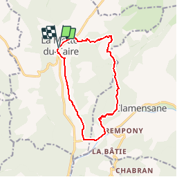
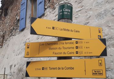
Tour Wandern von 13,1 km verfügbar auf Provence-Alpes-Côte d'Azur, Alpes-de-Haute-Provence, La Motte-du-Caire. Diese Tour wird von tracegps vorgeschlagen.
Beschreibung
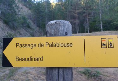
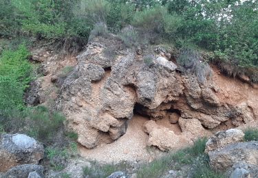
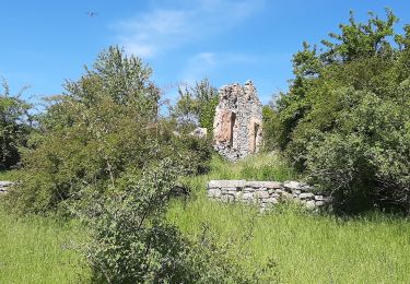
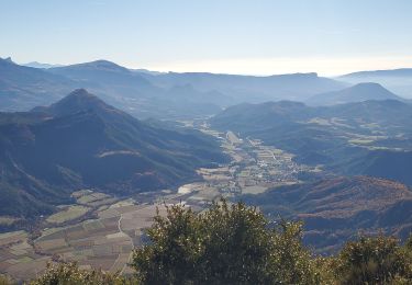
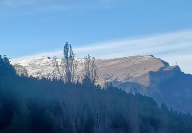
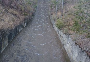
Au départ de la Motte du Caire, prendre la D951 en direction de Turriers. Bifurquer à droite 200m plus loin pour emprunter un sentier qui surplombe la vallée du Grand Vallon. Une heure trente plus tard, vous atteignez le plateau du grand Abian avec les ruines d’une grande ferme encore en activité au début du XXe siècle. Se diriger plein sud par la piste qui longe le rocher roux. Peu après, quitter cette piste sur votre gauche par un sentier en sous bois qui vous guidera jusqu’au moulin à plâtre de la Gypière. Rattraper la D1 que vous descendez en longeant la Sasse durant 1 km. Arrivé au Bas- Plan, prenez à l’intérieur du hameau la piste qui vous ramènera à la Motte du Caire. Téléchargez la fiche du circuit sur le site des Hautes Terres de Provence.
Ort
Kommentare
Touren in der Umgebung
![Tour Wandern Clamensane - Clamensane - Col de la Croix - Chapelle St-Amand - Photo](https://media.geolcdn.com/t/375/260/03bf31a1-ae5a-4bc8-81f0-352f4f7d4b3d.jpg&format=jpg&maxdim=2)
![Wandern Wandern](https://static1.geolcdn.com/sitytour/trail-icons/101.png)
Wandern
![](/images/other/stat-length.png)
![](https://static1.geolcdn.com/siteimages/upload/files/16400158638029165_repeat_loop_refresh_sync_direction_icon.png)
![Tour Wandern Clamensane - CLAMENSANE. TROU DU DIABLR . CHAPELLE S AMAND . COL LA CROIX . O L M S. IX - Photo](https://media.geolcdn.com/t/375/260/10d9eaa1-fd55-4233-9c4f-5d12e1744ffc.jpg&format=jpg&maxdim=2)
![Wandern Wandern](https://static1.geolcdn.com/sitytour/trail-icons/101.png)
Wandern
![](/images/other/stat-length.png)
![](https://static1.geolcdn.com/siteimages/upload/files/16400158638029165_repeat_loop_refresh_sync_direction_icon.png)
![Tour Wandern Clamensane - VALAVOIRE Pas de Palabiouse , bergerie de Premarche o l s - Photo](https://media.geolcdn.com/t/375/260/0c200d5e-0f59-43cc-96e6-d7b8947343f2.jpg&format=jpg&maxdim=2)
![Wandern Wandern](https://static1.geolcdn.com/sitytour/trail-icons/101.png)
Wandern
![](/images/other/stat-length.png)
![](https://static1.geolcdn.com/siteimages/upload/files/16400158638029165_repeat_loop_refresh_sync_direction_icon.png)
![Tour Wandern Clamensane - VALAVOIRE. Pas de Palabrouse. Fontaine de Pouille o l s - Photo](https://media.geolcdn.com/t/375/260/d94e99f0-0c27-4f39-bd9c-c7d2b68f013f.jpg&format=jpg&maxdim=2)
![Wandern Wandern](https://static1.geolcdn.com/sitytour/trail-icons/101.png)
Wandern
![](/images/other/stat-length.png)
![](https://static1.geolcdn.com/siteimages/upload/files/16400158638029165_repeat_loop_refresh_sync_direction_icon.png)
![Tour Wandern La Motte-du-Caire - LA MOTTE DU CAIRE .Le tour de la Blachere o - Photo](https://media.geolcdn.com/t/375/260/181c511a-92a7-4933-9888-9e2bc6024806.jpg&format=jpg&maxdim=2)
![Wandern Wandern](https://static1.geolcdn.com/sitytour/trail-icons/101.png)
Wandern
![](/images/other/stat-length.png)
![](https://static1.geolcdn.com/siteimages/upload/files/16400158638029165_repeat_loop_refresh_sync_direction_icon.png)
![Tour Wandern Melve - Melve Les Chanderettes 1014m 16kms - Photo](https://media.geolcdn.com/t/375/260/ccabf33a-e431-4ec0-8bfa-bcf63e55d70b.jpg&format=jpg&maxdim=2)
![Wandern Wandern](https://static1.geolcdn.com/sitytour/trail-icons/101.png)
Wandern
![](/images/other/stat-length.png)
![](https://static1.geolcdn.com/siteimages/upload/files/16400158638029165_repeat_loop_refresh_sync_direction_icon.png)
![Tour Wandern Clamensane - CLAMENSANE BERGERIE BERGIE ROCHER CHABRIER O S L - Photo](https://media.geolcdn.com/t/375/260/220e1021-cc5e-48e0-8055-b6a13c355da7.jpg&format=jpg&maxdim=2)
![Wandern Wandern](https://static1.geolcdn.com/sitytour/trail-icons/101.png)
Wandern
![](/images/other/stat-length.png)
![](https://static1.geolcdn.com/siteimages/upload/files/16400158638029165_repeat_loop_refresh_sync_direction_icon.png)
![Tour Wandern Le Caire - LE CAIRE . LES CHANTERETTES . O S . - Photo](https://media.geolcdn.com/t/375/260/aba8ae0f-8c6a-4c87-8860-907a21ce562c.jpg&format=jpg&maxdim=2)
![Wandern Wandern](https://static1.geolcdn.com/sitytour/trail-icons/101.png)
Wandern
![](/images/other/stat-length.png)
![](https://static1.geolcdn.com/siteimages/upload/files/16400158638029165_repeat_loop_refresh_sync_direction_icon.png)
![Tour Wandern Le Caire - LE CAIRE . Tour de la grande Fissore n - Photo](https://media.geolcdn.com/t/375/260/11db8b16-4efd-42ab-86ee-ef1389c19870.jpg&format=jpg&maxdim=2)
![Wandern Wandern](https://static1.geolcdn.com/sitytour/trail-icons/101.png)
Wandern
![](/images/other/stat-length.png)
![](https://static1.geolcdn.com/siteimages/upload/files/16400158638029165_repeat_loop_refresh_sync_direction_icon.png)